Satellite Technology Revolutionizes Monitoring of Coastal Seagrass Ecosystems
Satellite Technology Revolutionizes Monitoring of Coastal Seagrass Ecosystems
Seagrass meadows represent some of the most vital and dynamic ecosystems along our planet’s coastlines. These submerged flowering plants not only act as significant carbon sinks, storing vast amounts of blue carbon, but they also nurture biodiversity by providing nursery habitats and shelter for a wide variety of marine organisms. Despite their ecological importance, these habitats are increasingly imperiled due to climate change, coastal development, and pollution. Monitoring the health and distribution of seagrass ecosystems has remained a persistent challenge for marine scientists, largely because these underwater meadows are difficult to distinguish from adjacent coastal vegetation types such as mangroves and salt marshes, especially when tidal fluctuations constantly reshape the environment.
Traditional remote sensing approaches have struggled to achieve high accuracy in seagrass mapping due to the spectral similarity among various intertidal vegetation and the complex influence of tidal dynamics. The challenge lies in differentiating seagrass from mangroves, salt marshes, tidal flats, and seawater merely based on optical imagery, which can often be obscured or distorted by water turbidity and variations in water depth. Conventional supervised classification methods require extensive training datasets and manual intervention, which limits scalability and hinders the ability to monitor seagrass meadows at global scales in near-real time. Addressing these limitations necessitates innovative methods that can integrate multiple remote sensing modalities and automate the classification process.
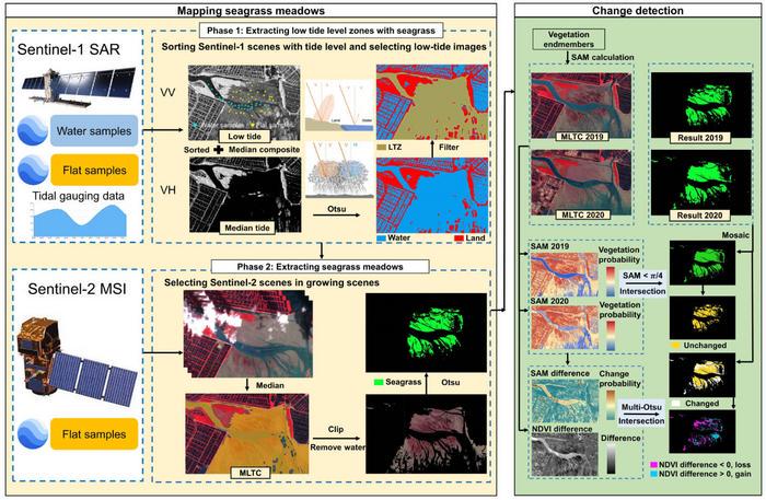
In a groundbreaking study published in the Journal of Remote Sensing in early 2025, a multinational research team hailing from Xiamen University and Tulane University introduced the Automatic Mapping through integrating Optical and SAR images for intertidal Seagrass meadows (AMOSS) algorithm. This novel approach uniquely leverages the complementary strengths of Sentinel-1 Synthetic Aperture Radar (SAR) and Sentinel-2 optical imagery to unravel the complex biophysical, spectral, and tidal characteristics of seagrass meadows in global intertidal zones. By harnessing both radar backscatter properties and optical spectral signatures, AMOSS overcomes the longstanding challenge of vegetation spectral confusion and tidal masking.
A critical insight underpinning AMOSS lies in the distinct physical structure differences between seagrasses and other intertidal vegetation such as mangroves and salt marshes. Unlike these terrestrial-adapted plants possessing upright stems or trunks, seagrasses exhibit a predominantly horizontal growth pattern lacking tall, rigid structures. This morphologic distinction directly influences radar backscatter signals, particularly in the VH polarization mode of Sentinel-1 SAR data. Seagrasses produce notably lower backscatter coefficients in VH polarization compared to mangroves and salt marsh plants, which AMOSS leverages as a primary rule-based discriminator to separate seagrass from other vegetation types in radar images.
To enhance classification precision, the research team integrated a multistep image processing workflow. Initially, the Otsu thresholding algorithm was adopted to automatically delineate low-tide zones (LTZ)—coastal regions exposed during low tide where intertidal seagrass meadows predominantly occur. This step effectively localized the target areas for seagrass mapping and reduced omission errors caused by tidal submergence. Subsequently, a multi-binary classification approach refined the identification of seagrass amidst neighboring land cover types, combining the radar signature thresholds with spectral responses derived from Sentinel-2’s multispectral bands.
Importantly, AMOSS incorporates a temporal change-detection mechanism using the Spectral Angle Mapper (SAM) method. By comparing spectral reflectance angles between baseline and subsequent optical scenes, the algorithm detects seagrass loss and recovery trends over time, offering unprecedented insights into ecosystem dynamics and resilience. This capability is especially vital for assessing the impacts of episodic disturbances such as storms, pollution events, or anthropogenic interventions and informing adaptive conservation actions.
The efficacy of AMOSS was rigorously evaluated across 15 diverse global study sites spanning tropical to sub-polar latitudes—including critical coastal zones known for rich intertidal biodiversity. The algorithm consistently achieved an overall classification accuracy of approximately 84%, a remarkable performance considering the complexity of mixed vegetation and water backgrounds. This accuracy level not only rivals but often surpasses that of supervised classification methods, which typically require laborious field data collection and manual labelling of training samples.
Beyond its high accuracy, AMOSS’s fully automated structure renders it scalable and highly transferable, streamlining large-scale ecological monitoring efforts. This represents a paradigm shift from labor-intensive, localized studies toward continuous global seagrass surveillance, enabling scientists and policymakers to identify and respond to habitat changes more swiftly and effectively. The algorithm’s avoidance of manual sample selection significantly expedites processing time and reduces subjectivity, which historically have constricted monitoring productivity.
The research team emphasized that AMOSS’s integration of optical and SAR imagery exploits the intrinsic complementary attributes of these sensors: optical data captures spectral features sensitive to vegetation pigmentation and health, while radar data is robust against atmospheric conditions and captures structural properties. This synergy is particularly advantageous in intertidal zones where water influence varies temporally and spectrally, often confounding single-sensor mapping techniques.
Looking forward, AMOSS opens the door for next-generation applications including near-real-time monitoring platforms that could provide early warning signals of seagrass decline or degradation. By embedding this technology into national and international conservation frameworks, governments and environmental organizations may vastly improve their capacity to safeguard these vulnerable ecosystems amid escalating climate and anthropogenic pressures. Such enhanced monitoring capabilities will also contribute directly to international commitments like the United Nations Sustainable Development Goals related to life below water and climate action.
Furthermore, the algorithm’s rule-based design equips it to be adaptable for integration with emerging satellite constellations and airborne remote sensing systems, potentially refining spatial-temporal resolutions and advancing precision further. As coastal ecosystems globally face mounting threats, tools like AMOSS represent pivotal advancements in our surveillance arsenal, empowering scientists with clearer, more actionable data for ecosystem management, restoration, and policy formulation.
In conclusion, the AMOSS algorithm signifies a transformative leap in the remote sensing of intertidal seagrass meadows. By combining radar and optical data within an automated, scalable analytical framework, it transcends the limitations of previous methodologies to deliver accurate, efficient, and continuous monitoring of these critical habitats worldwide. Its success underscores the potential of multidisciplinary remote sensing strategies to resolve complex environmental challenges and highlights the vital role of technological innovation in marine conservation.
Subject of Research: Not applicable
Article Title: A Rule-Based Automatic Approach for Mapping Intertidal Seagrass Meadows Using Optical and Synthetic Aperture Radar Images
News Publication Date: 2-Apr-2025
References:
DOI: 10.34133/remotesensing.0506
Image Credits: Journal of Remote Sensing
Keywords: Seagrasses
Inaugural International Conference on Cyborg and Bionic Systems: A Leap into the Future of Bioengineering
Next PostUnveiling FMRP’s Dual Impact: Driving Tumor Progression and Therapy Resistance in Cancer Biology
Related Posts

Scilly Isles Cameras Offer Rare Glimpse into Britain’s Untouched Marine Ecosystems
Scientists Uncover Molecular Structure and Enhanced Light Harvesting in Largest Eukaryotic Photosystem Complex
Applied Microbiology International Launches New Conservation Committee Urging Scientific Community to Embrace Microbial Preservation
Dynamic Ion Transport Theory in Electrochemical Ion Pumping
New Study Unveils the Dynamic Movements of Wild Octopus Arms