Satellites Reveal Fresh Insights into Chesapeake Bay’s Marine Heat Waves
Satellites Reveal Fresh Insights into Chesapeake Bay’s Marine Heat Waves
Marine Heat Waves Reshape the Chesapeake Bay: A New Window into Estuarine Climate Dynamics
Heat waves have long been notorious for their devastating impacts over terrestrial landscapes, scorching crops, intensifying wildfires, and imperiling human and wildlife health. Yet, the phenomenon of heat waves is not confined solely to the land. Vast aquatic domains, including oceans and estuaries, experience episodic and persistent warming events known as marine heat waves (MHWs) that can last from weeks to several years. These events disrupt marine ecosystems, influence species distribution, and alter biogeochemical cycles. A striking example of such an event was the infamous “Blob,” a massive marine heat anomaly that emerged in the northeastern Pacific Ocean from 2013 to 2016, profoundly affecting oceanic life and fisheries across the U.S. West Coast.
Building upon this conceptual framework, a team of researchers led by the University of Maryland has unveiled pioneering findings on the increasing prevalence and spatial complexity of marine heat waves in the Chesapeake Bay, one of the most significant estuarine systems along the U.S. eastern seaboard. Leveraging over two decades of satellite-derived sea surface temperature data, their study, published in the journal Estuaries and Coasts, meticulously quantifies the frequency, duration, and spatial heterogeneity of heat waves across this intricate estuarine environment.
The Chesapeake Bay’s vulnerability to marine heat waves has escalated noticeably over the last 20 years. On average, the bay endures approximately 25 days annually subjected to marine heat waves, but recently, a nearly 10% increase was recorded between 2003 and 2022. Although seemingly modest, this increment translates to two to four additional MHW events per decade, a change with profound implications for the bay’s delicate ecological balance. The subtle yet relentless upward trend in thermal stress is emblematic of broader climatic shifts increasingly manifesting in coastal and estuarine systems globally.
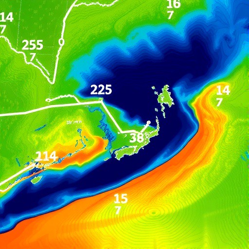
Different portions of the Chesapeake Bay exhibit distinct patterns of marine heat wave behavior. Analysis of the satellite datasets — encompassing contributions from NASA, NOAA, and the European Union Space Programme — revealed a spatial dichotomy in MHW dynamics: the lower bay region, stretching about 1,500 square miles south of the Potomac River, experiences fewer heat waves, yet these events tend to be prolonged. Conversely, the upper bay undergoes more frequent, but shorter, bursts of elevated temperature. This spatial variability suggests that local environmental drivers, including hydrodynamics, freshwater influx, and atmospheric conditions, interact to produce a complex mosaic of thermal anomalies.
The implications of this spatial heterogeneity extend beyond mere temperature statistics. The timing, frequency, and intensity of marine heat waves exert outsized influence on estuarine biota, particularly ectothermic species whose physiological processes are temperature-sensitive. For instance, key recreational and commercial fish species like striped bass rely on thermally suitable conditions for successful spawning and hatchling survival. Elevated water temperatures during critical periods can suppress spawning activity, diminish recruitment success, and alter species distributions, cascading into long-term ecosystem ramifications and economic impacts for fisheries.
The research highlights marine heat waves during spring as particularly consequential. Even a single additional heat wave at this time can disrupt recruitment processes — the replenishment of juvenile fish populations — setting back population growth for the entire year. Given that estuaries such as the Chesapeake serve as nurseries for many marine species, understanding these heat waves is crucial for conservation strategies and fisheries management.
Methodologically, this study represents a paradigm shift in the monitoring of estuarine thermal dynamics. Historically, marine heat wave research and temperature monitoring relied heavily on in situ observations gathered from buoys and vessel transects, which are often spatially sparse and logistically challenging in complex estuarine settings. By contrast, the UMD-led team demonstrated that high-resolution satellite remote sensing, despite estuaries’ relatively narrow and optically complex waters, can serve as an effective and scalable tool for detecting, characterizing, and mapping MHWs with unprecedented spatial coverage.
This advancement in satellite application is more than a proof of concept; it expands the frontiers of remotely sensed climate data by applying it to constrained water bodies, where traditionally, coarse satellite pixel sizes limited utility. The ability to monitor MHWs via satellite opens avenues for real-time ecosystem assessment, timely resource management, and the potential establishment of early warning systems for marine heat wave hazards. Such programs would harness publicly available NOAA and NASA satellite data products to provide continuous, accessible thermal information crucial for protecting the Chesapeake Bay’s ecological and economic assets.
Intriguingly, despite clear spatial patterns in frequency and duration of MHWs across the Chesapeake, the underlying physical mechanisms remain elusive. Researchers hypothesize that multifaceted interactions among oceanic intrusions at the bay’s mouth, variable riverine inputs, meteorological forcing, and estuarine circulation dynamics all contribute variably along the estuarine gradient. Disentangling these drivers requires further interdisciplinary research combining hydrodynamic modeling, atmospheric science, and long-term observations, potentially unlocking predictive capabilities for future heat wave occurrences.
Beyond its scientific novelty, this research underscores the critical role of open, publicly funded satellite datasets in climate science and environmental stewardship. As Rachel Wegener, the study’s lead author, articulated, these data extend benefits far beyond academic insight, touching societal sectors as varied as public safety, fisheries, recreational activities, and climate policy development. The transparency and accessibility of data managed by agencies such as NOAA enable continuous monitoring and research that underpin adaptive management in the face of anthropogenic climate perturbations.
The study also aligns with emerging calls from regional governing bodies like the Chesapeake Bay Program’s Scientific and Technical Advisory Committee for the development of a marine heat wave warning system specifically tailored for the bay. Such a system would integrate satellite observations to provide timely alerts, helping mitigate ecological damage, optimize fisheries operations, and inform public stakeholders about thermal stress risks. This proactive approach reflects a broader trend in climate adaptation strategies that leverage technological advances in Earth observation.
Furthermore, the Chesapeake Bay findings contribute valuable insight to the global understanding of marine heat waves’ ecological consequences, complementing observations from larger open ocean systems. The estuarine focus exposes unique estuarine processes and vulnerabilities often masked in broader oceanographic analyses, emphasizing the necessity for localized studies. Given the disproportionate importance of estuaries for biodiversity and human livelihoods, such targeted research is imperative.
In sum, this pioneering investigation into the Chesapeake Bay’s marine heat wave patterns illuminates emerging climate stressors on estuarine ecosystems and exemplifies innovative methodological approaches in climate science. By revealing nuanced spatial variability and linking heat wave dynamics to key ecological processes, the research not only advances scientific knowledge but also lays the groundwork for applied environmental management, showcasing the essential synergy between satellite remote sensing and ecosystem stewardship in an era of accelerating climate change.
Subject of Research: Not applicable
Article Title: Spatial variability of marine heatwaves in the Chesapeake Bay
News Publication Date: 22-May-2025
Web References:
- The Blob feature story – NOAA Fisheries
- Chesapeake Bay Program STAC Report (2023)
References:
- Wegener, R., Lama, S., Wenegrat, J., & Lance, V. (2025). Spatial variability of marine heatwaves in the Chesapeake Bay. Estuaries and Coasts.
Keywords: Ocean warming, Ocean temperature, Ocean surface temperature, Air sea interactions, Climate change, Climate data, Anthropogenic climate change, Climate change mitigation, Climate systems, Hydrosphere, Marine ecosystems, Marine ecology, Meteorology, Weather, Extreme weather events, Heat waves
Philosophy-Based Teaching Boosts EFL Learners’ Skills
Next PostMachine Learning Predicts Groundwater Sustainability in Semi-Arid Aquifers
Related Posts

Powerful Dechlorination of Pollutants by Cobalamin and Iron
New Study Connects Atmospheric and Oceanic Processes in Weathering and CO2 Removal
Reusable Photocatalytic Film Boosts Low-Light Water Disinfection
Kelp Forests: Vital Links to Local Beach Ecosystems
How Charge Uniformity Enhances Ion Selectivity in Membranes