
This 300-Mile Coastal Trail Lets Hikers Explore Ancient Ruins, Sapphire Waters, and Rugged Peaks,
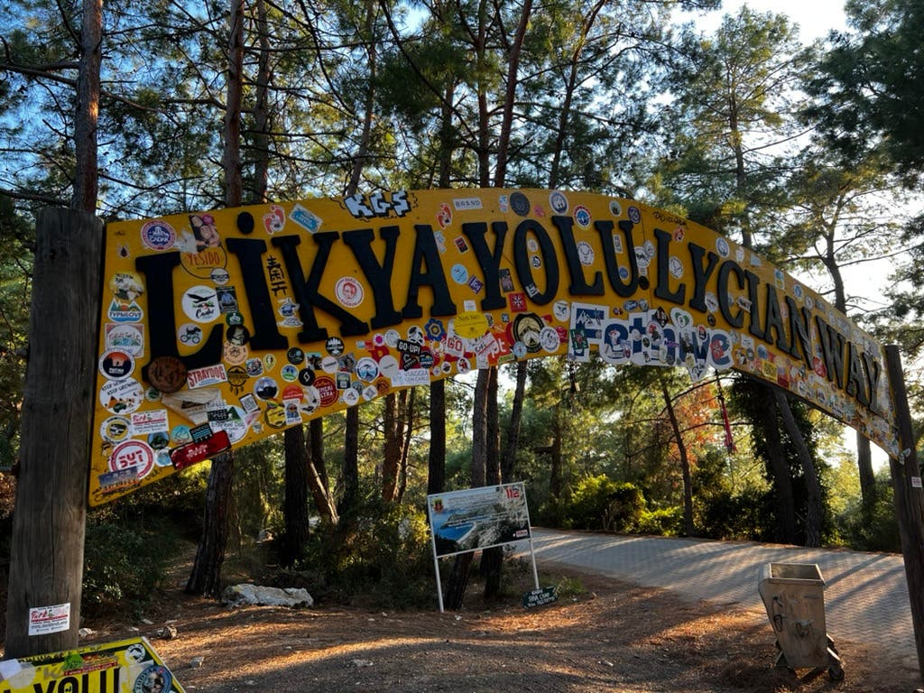
Stretching more than 300 miles along Turkey’s southern coast, the Lycian Way connects dozens of ruins of ancient seaside cities. Documented in the late 1990s by British expat Kate Clow, the route stitches together a network of old mule paths, shepherd routes, and Roman roads to create a Mediterranean trail like no other.
Here’s a breakdown of the trail’s highlights—archaeological, natural, and cultural—so you can better understand what you’ll actually experience underfoot, and which sections best match your interests and hiking style.
What are the highlights of hiking the Lycian way?
The Lycian Way is an open-air museum. History, landscape, and living culture overlap day after day, sometimes within the same mile. One moment you’re scrambling past a Roman aqueduct. The next you’re swimming in turquoise water or eating dinner in a mountain village.
Ancient Cities Underfoot
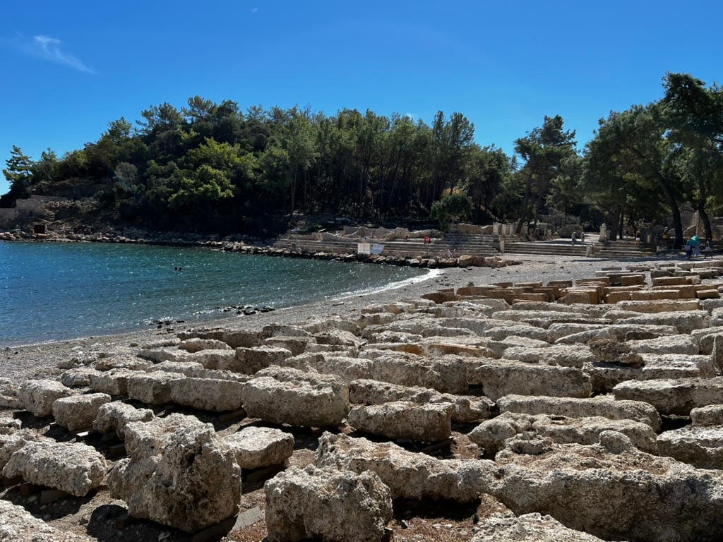
Few long trails weave archaeology so directly into the walking experience. The Lycian Way passes through—not just near—a string of ancient cities dating back to the fourth century BC. In Olympos, ruins from both the Lycian and Roman eras lie scattered through a jungle-green valley that opens onto a quiet beach. Phaselis pairs crumbling stone streets and harbors with some of the most inviting swimming spots on the coast, while Myra and Aperlai reveal the scale of Lycia’s former trading power in their monumental tombs and theaters.
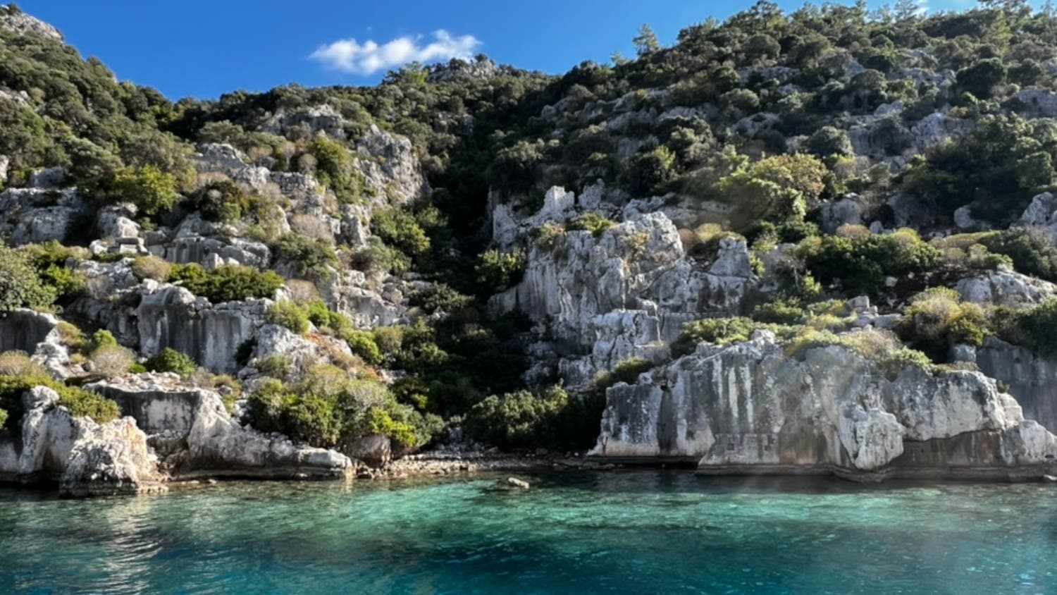
Elsewhere, the trail skirts the acropolis of Xanthos, once the political heart of the Lycian League, and winds past the partially submerged ruins of Simena and Kekova, where ancient walls disappear into the sea just offshore.
Coastlines, Canyons, and Fire
The natural scenery is just as varied. Much of the route traces cliffs high above the Mediterranean, where the water shifts from deep blue to neon turquoise. Inland detours lead to places like Yanartaş, where the natural gas fires known as the eternal flames of Chimaera flicker from the mountainside — a phenomenon sailors once used as a navigational beacon. (Today, hikers are more likely to use them for marshmallows or tea.)
Other highlights feel equally improbable: Butterfly Valley, a sheer-walled canyon alive from May to September with the fluttering wings of Jersey tiger moths; the cool depths of Saklıkent Gorge, one of Turkey’s longest and deepest; and the iconic crescent of the resort village Ölüdeniz, often visible from hundreds of feet above on exposed ridgelines. Higher still, the trail climbs toward Mt. Tahtalı (one of a number of mountains known as Olympus in ancient times), topping out around 7,750 feet, where alpine views replace sea spray.
How village to village hiking keeps the trail alive
Unlike Europe’s hut-to-hut routes or the backcountry-heavy trails many American hikers are used to, the Lycian Way runs straight through living, working villages. You don’t hike all day and disappear into the wilderness; you hike into someone’s home base—often a small, family-run pension where dinner simmers on the stove and breakfast is already planned for the morning.
“The villages have changed quite a lot,” says Clow. “When I started making the trail in the early 1990s the villages were dependent on local agriculture.” That changed as hikers began passing through: “Having made the trail, the villages along the trail began to recover, because people started to open accommodation, cafes, things like that for the walkers.”
Today, most Lycian Way itineraries are designed around these village stops. Accommodation typically comes in the form of pensions—simple guesthouses run by local families.
According to Els Hom of Middle Earth Travel, what they lack in luxury, they make up for in reliability. “You need a good bed and a good shower and good food—especially good food,” she says. These home-cooked meals are a highlight: Think a Turkish breakfast spread of olives, eggs, fresh bread, and local honey in the morning, followed by home-cooked kebabs at night.
Logistically, these village stays make the Lycian Way far more approachable than its rugged terrain might suggest. Most guided and self-guided trips include luggage transfer, meaning hikers carry only a daypack while their main bags shuttle to the next stop.
Camping, meanwhile, isn’t necessarily the budget workaround many hikers assume it will be. For guided groups, it can actually cost more.
“If there is a group really interested in doing camping on the site, we also do that,” says Lara Işın of Equinox Travel. “But it makes the costs a little bit higher, because we need to hire some more staff. And they go to the camping site before the group—they prepare everything, like the dinners, the tents and everything.”
What are the best hiking routes on the Lycian Way?
Thru-hiking the Lycian Way end to end takes a bit more than a month, but most hikers don’t approach it that way.
“We try to categorize the trails regions like the Eastern Lycia, the Western Lycia, the Central Lycia—and we try to keep the trekking tours about a week long,” says Işın
Here’s what to expect from each segment of the trail.
Western Lycian Way
Best for: First-timers, sea views, cultural ruins, moderate effort
Air access: Dalaman Airport
Known for its sea views, the western section is widely considered the most approachable introduction to the Lycian Way. Distances between villages are shorter, trail access is easier, and accommodations are plentiful—without sacrificing scenery or history.
According to Uraz Nehir, owner of Cicerone Travels, highlights of this portion of the trail here include Kayaköy, a “ghost town” near Fethieye that was abandoned by the Greek Orthodox inhabitants during a population exchange with Greece. Hikers can pause at the most photographed part of the Lycian way, the famed overlook of Ölüdeniz beach town, where paragliders sail overhead. Hikers in this region often pass through agricultural land and quiet coastal paths.
Fatih Koç, a guide with Overland Travel, describes the Alınca to Sidyma section as a study in contrasts: sweeping sea views give way to Mediterranean pine and juniper forests, open grain and barley fields, and treks the ruins of tombs, bathhouses, and churches.
Infrastructure in the west is excellent by Lycian Way standards, with frequent pensions and strong support for luggage transfers, guided hikes, and self-guided itineraries.
Central Lycian Way
Best for: Cultural depth, fewer tourists, off-the-beaten-path charm
Air access: Antalya or Dalaman (with a longer transfer)
“It takes longer to get there because there’s no airport in the center of the region,” says Hom. “There’s only one in Antalya and one in Dalaman. And if you want to travel to the central part of the Lycian Way, it takes two hours to get there.”
What you gain in exchange is access to some of the trail’s most evocative places. The density of historical sites defines the central section of the Lycian Way. The ancient Delikkemer aqueduct slices through the rolling hills toward the ruins of Ancient Patara along sparkling bays. Nehir also recommends stopping at the Church of St. Nicholas, an archaeological museum dedicated to the saint that inspired Santa Claus. Terrain here is mixed—some days mellow and pastoral, others rocky and remote—and logistics require a bit more planning.
Another defining feature of Central Lycia is the ability to combine hiking with boat travel. Equinox’s itinerary here, for example, includes a hike that ends at the sea: “We visit the ancient city of Apollonia and descend to the ancient city of Aperlai, where our boat awaits us.” From there, travelers continue through the Kekova region by water, passing sunken ruins just offshore.
Eastern Lycian Way
Best for: Experienced trekkers, mountain solitude, alpine ecosystems
Air access: Antalya Airport
The eastern section is the most demanding—and for many hikers, the most rewarding. This is where the Lycian Way climbs decisively into the mountains, with longer days, more elevation gain, and fewer exit points.
“There are a couple of days that are absolutely out in the wild and on the mountains,” says Hom. “There’s no or not a lot of easy access — you have to finish what you start.”
Eastern Lycia’s highlights include Mt. Tahtalı (Lycian Olympus), the Beydağları Mountains, and high, exposed routes leading to places like Gelidonya Lighthouse, Turkey’s highest lighthouse perched above the sea. Starting from the necropolis of Olympos beach, you can steadily climb through the forest covered with Turkish pine and Mediterranean strawberry trees to Mt. Moses.
As hikers climb, the vegetation shifts dramatically. “On the higher sections we get cedar trees,” says Clow. “They were the tree that made Lycia rich, because the inhabitants used to cut them and export them to Egypt and Greece for shipbuilding.”
Accommodations are fewer and farther apart here, and most hikers opt for guided or supported treks. But for those with the fitness and preparation, the eastern section delivers a wilder, more alpine side of the Lycian Way—one that feels worlds away from the beach towns below.
When is the best time to hike the Lycian Way?
Best Seasons: Spring and Fall
For most hikers, the Lycian Way shines in spring (March through May) and fall (late September through early November). Spring brings cooler temperatures, green hillsides, and a burst of wildflowers along the trail.
“I personally [prefer] spring—as early as possible, February, March—because it’s the best season for flowers,” says Clow.
Fall offers similarly mild hiking conditions, with the added bonus of a warm Mediterranean. Sea temperatures stay comfortable well into October, making post-hike swims possible on coastal sections. Crowds thin out after summer, and the days remain long enough for full hiking itineraries without the oppressive heat.
Shoulder-Season Caution
Early spring and late fall can be excellent—but they require flexibility. Rain is more common, daylight is shorter, and some high-elevation passes may be uncomfortable or unsafe depending on conditions. Most operators adjust routes accordingly, favoring lower sections when needed.
When Not to Go: Summer
July and August are widely considered the worst—and most dangerous—months to hike the Lycian Way. Daytime temperatures routinely soar, shade is scarce, and reliable water sources are limited. Wildfire risk is also at its peak, especially in forested areas.
Local guides are universally blunt: Summer heat slows hikers dramatically and increases the risk of dehydration, heat exhaustion, and navigation errors. While short early-morning walks are possible near the coast, sustained dayhikes are strongly discouraged.
The Gear You Need for the Lycian Way
The Lycian Way may trace a sunny Mediterranean coastline, but it’s not an easy stroll. Much of the trail is steep, rocky, and exposed, with long stretches far from reliable water.
“Very often people say, ‘We’ve walked the Camino, we’ve walked in Portugal or in Spain or in France, and we can do 20 kilometers a day,’” says Hom. “And then we reply, ‘Yeah, of course, on those trails, you can, but you can’t on the Lycian Way because it’s rather steep and rocky and lots of loose stones, and the terrain is uneven. You have to take that into account when you walk, that you go slower.’”
Footwear
The single most important gear choice on the Lycian Way is what you put on your feet. Limestone dominates the terrain, and loose stones, scree, and uneven steps are constant. Sturdy hiking boots with good traction and ankle support, are the best for hikers, especially on long descents. Waterproofing helps in spring, when rain turns rock slick. Experienced hikers can manage in low-cut shoes, but this is not a forgiving trail for minimalist footwear.
Water Carrying
Water planning is critical. Natural sources are sparse or nonexistent on many sections, particularly in summer and fall. On supported or guided trips, water is often resupplied from vehicles or pensions, but independent hikers should expect to carry two to three liters per day or more. Underestimating water here is one of the fastest ways to cut a hike short.
Daypack
Even on trips with luggage transfer, hikers often carry everything they need during the day. A proper daypack with good back support is essential for hauling water, food, and layers over uneven terrain. You’ll want room for snacks or a packed lunch, sun protection, extra clothing, and—on coastal sections—a swimsuit and small towel for post-hike swims.
Clothing
Temperatures can swing quickly from cool mornings to hot, exposed climbs by midday. Lightweight, breathable layers work better than bulky insulation. A thin, wind-resistant outer layer goes a long way on ridgelines, while moisture-wicking base layers help manage sweat. Extra socks and a spare shirt can make a long day feel far more manageable.
Navigation and Safety
Trail markings exist but aren’t always consistent, especially in remote or recently rerouted sections. An offline navigation app (such as Gaia GPS) is strongly recommended if you are hiking without a guide. Trekking poles are optional but helpful on steep scree descents. A basic first-aid kit, headlamp, whistle, and sun protection round out the essentials.
What You Can Skip
Unlike many long-distance trails, the Lycian Way doesn’t require carrying heavy cooking gear or large food loads. Village meals are the norm, and accommodations are frequent. Large water filters and excessive spare clothing add weight without much benefit.